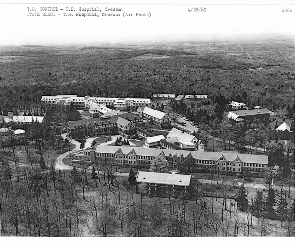
The 5 grayscale aerial photos shown below, dated 4-26-1960, were provided
by the Pa. State Archives. These photos show how the san complex looked when I was discharged in 1956.
CRESSON SAN AND THE COAL MINE CONNECTION
These 1960 aerial views of the san brought back memories of one of my favorite
past-times. When my buddy Jim Hammond and I made meals in 1956 we would often spend an afternoon walking in the woods
around the san. We soon discovered that if you started walking toward the east, you would quickly pass through a fairly
narrow stand of trees and suddenly come to the edge of an immense ravine running north and south across your path.
The ravine was long and deep and seemed all the more startling because it was almost devoid of vegetation. It was like
walking out of a forest onto a desolate moonscape.
This moonscape was actually an open strip coal mining operation which had been shut down
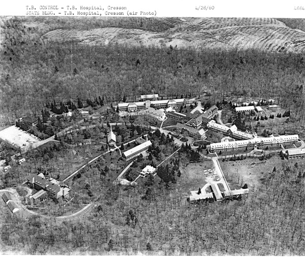
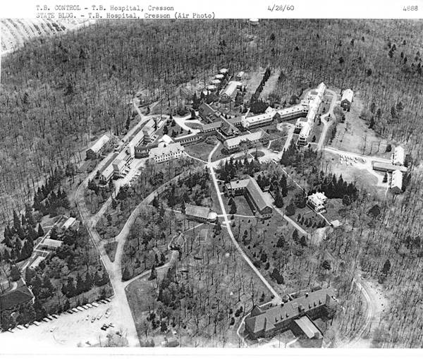
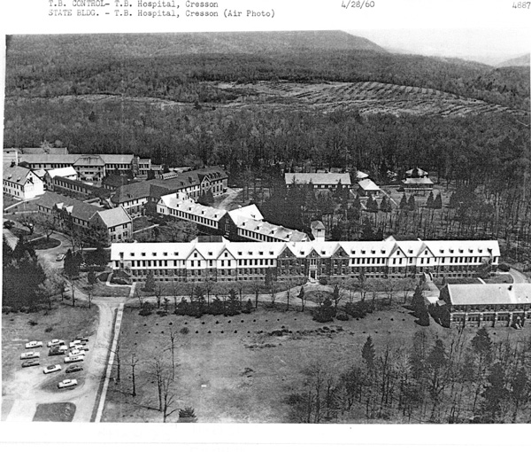
long before 1956. If you look at photos #1 & #2 you will see the bare patch of land at the top (looking
east), which was the strip mine. I believe the neatly laid out black stripes are actually rows of small
trees planted in an effort to reduce soil erosion and to restore the natural beauty of the land. Maps #3 &
#4 are current satellite maps obtained from the TerraServer USA website. On these maps, east is to the
right.
The #3 satellite map clearly shows the tree darkened area to the east of the san where
the strip mine was located. The #4 topological map shows the position of the san buildings and the strip
mine area, shaded brown, to the east. I'm not sure what the purple area indicates.
Photos #1 thru #4 just verify what I already knew about the strip mine.
But, in researching the Cresson sanatorium/coal mine connection, I did discover something completely unknown to me.
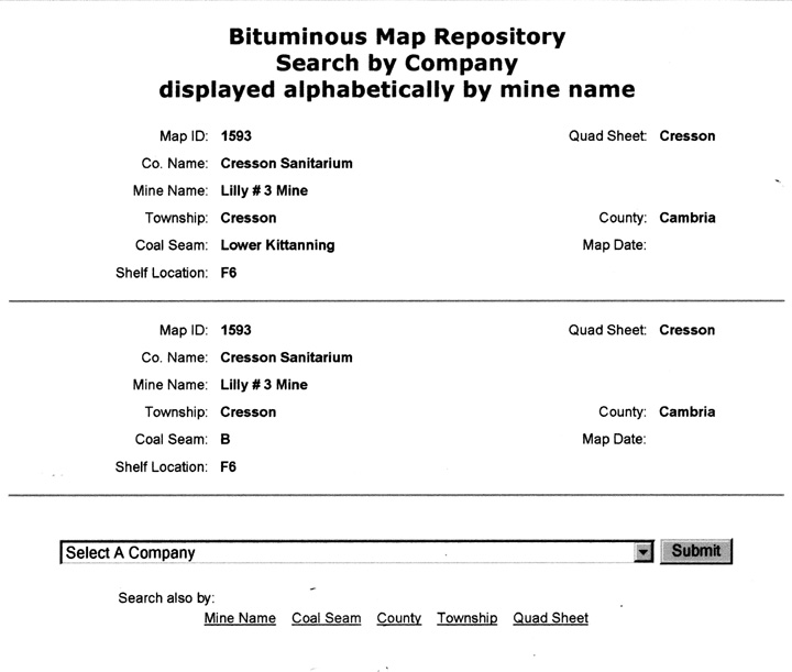
By searching the internet, I discovered that the Pa Dept of Mine Safety keeps maps of all mining operations, even those that
have ceased operation. Photo #5 shows a listing from their website showing that the coal mines at Cresson are listed
with Map ID #1593 and are designated by the company name of "Cresson Sanatorium". I called the map repository
in Uniontown, Pa. and talked with an agent who explained to me that in addition to the strip mine east of the san, there were
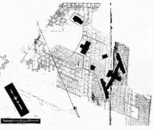
also mining operation tunnels that ran under the san grounds! They emailed me a section of Map ID #1593, shown in Photo
#6. The san buildings can be clearly seen on their map. The slanted lines are where coal mining operations
have taken place in the past, running completely under the san grounds.
This information clears up a long standing question I have had since 1956. For as Jim and
I walked along the Cresson side of the strip mine ravine, we came to several mine entrances which pointed righted back
to the san. They were posted with the usual "Keep Out" and "Warning Danger" and "Do Not Enter" signs in big bold letters.
But hey, we were TB survivors and nothing like an old abandoned mine shaft could hurt us. We entered the mine and walked
into them for a short distance, but the available sunlight limited our exploration to about 50 feet. But we always
wondered how far back they went toward the san. Now it appears they extended all the way under the san grounds.
Another mystery solved through the miracle of the internet. Now I wonder if I can find out when those mining operations
took place. Back to the internet!
Note: In case you are wondering, I have already contacted the Pa Department
of Corrections (DOC) and verified that the existance of the mine tunnels under the present correctional facility is public
knowledge. I don't want to be accused of aiding and abetting a jail break. The DOC website for the Cresson Facility
is
http://www.portal.state.pa.us/portal/server.pt/community/hide_cresson/11319
|
#1 East is at top of photo 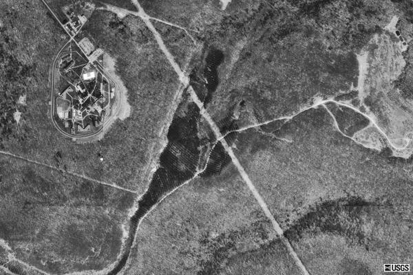
#3 TerraServer USA photo. East is at right of photo
#5 Dept of Mine Safety Map Listing
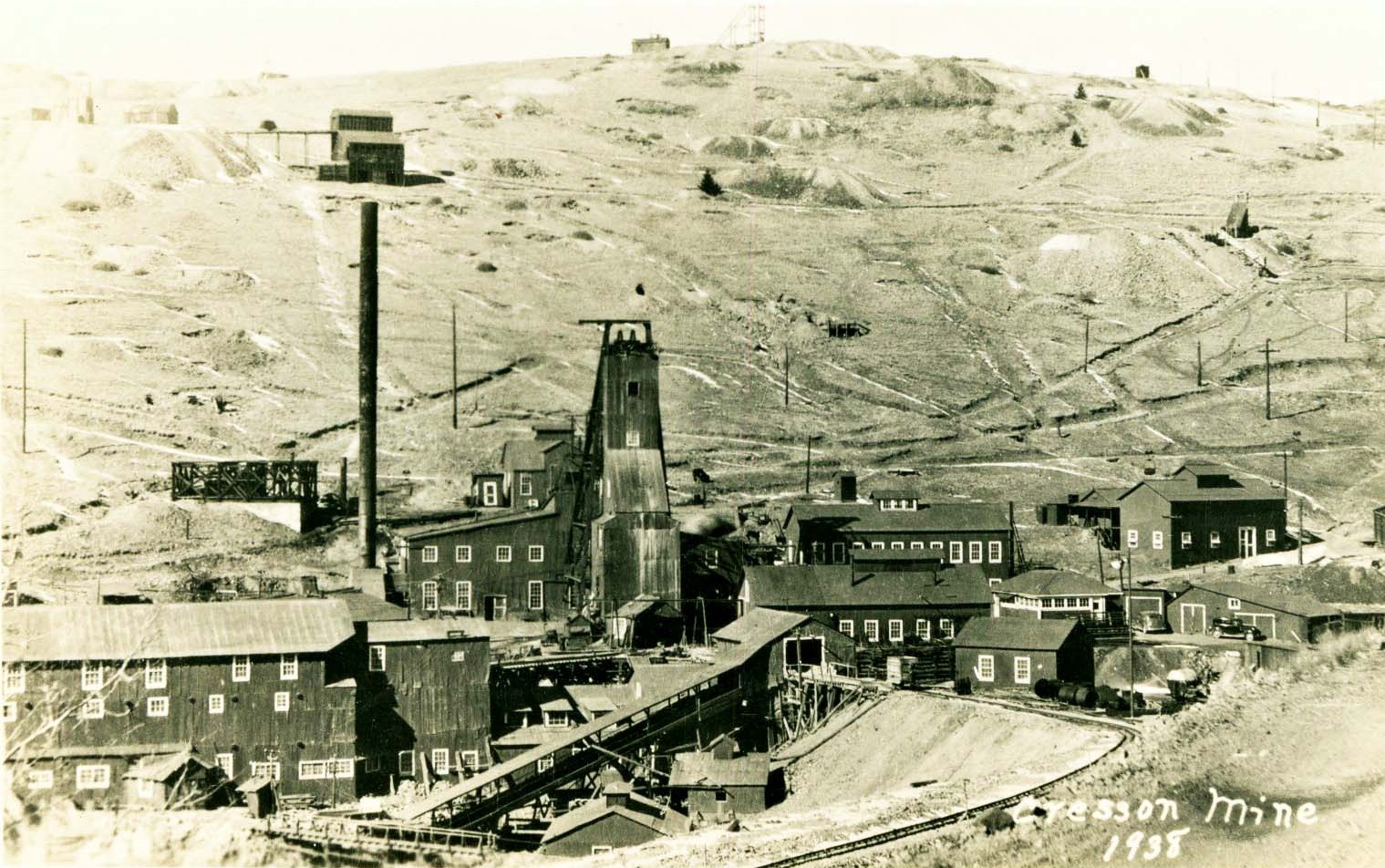
#7 Depicts the Cresson Mine in 1938 and shows mine shafts and
other surface features associated with the underground mine shafts which went beneath the sanatorium grounds. The
bare hillside is just a result of clear cutting the trees and is typical of many areas of Pennsylvania in the early 20th Century. The strip mining operation was probably started in a later decade well after this
photo was taken.
My thanks to Keith Previc,
Bureau of Mining and Reclamation
Harrisburg, PA 17105
#8 East is at bottom of photo.
#10. East is to the left.
____________________________________
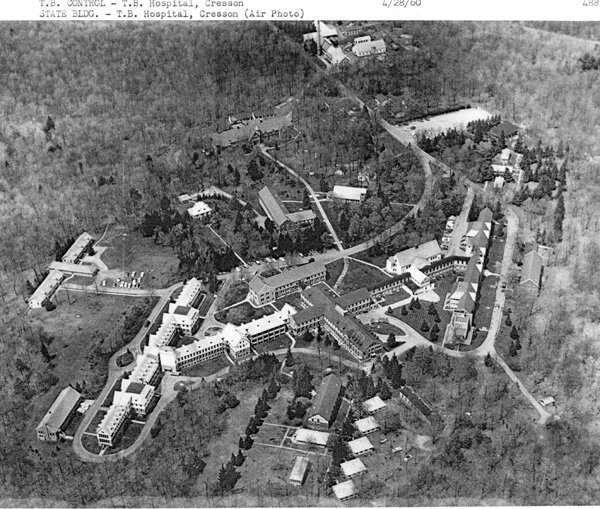
Cresson Water Tank
There was a large water tank located on the sanatorium grounds just south
of the san buildings which was the source of water for the complex. You can see it in photo #10 above at the very top
edge. It's also shown in Photos #3 & #4. After we made meals, Jim Hammond and I would occasionally climb the
tank for a spectacular view of the san grounds and surrounding countryside.
I found a reference to the water tank in the following book:
History of Cambria County, Pennsylvania
By: John E. Gable
Historical
Publishing Company
Topeka-Indianapolis, 1926
|
 |
|
|
|
|
#2 East is at top of photo 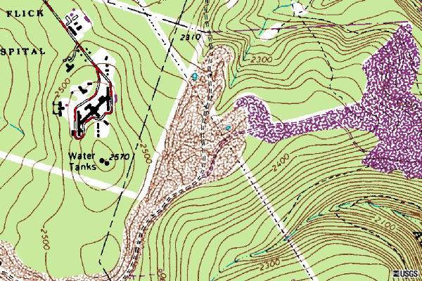
#4 Topographical Map. East is at right of map
#6 Map of Cresson Sanatorium Mine. East at right of photo
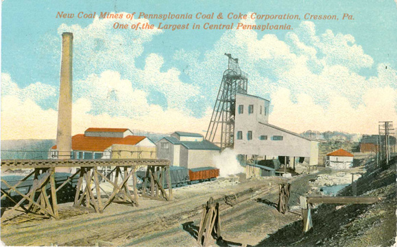
#7.5 This postcard shows the same basic view as Photo
#7. The caption on the front reads: "New Coal Mines of Pennsylvania Coal & Coke Corporation, Cresson, PA.
One of the Largest in Central Pennsylvania."
The postcard was mailed October 31, 1912 from the Irvona &
Cresson Rural Post Office with a one cent stamp to Wilmore, PA.
The postcard was published by Study's Drug Store, Cresson, PA.
#9 East is at right of photo.
#11. The above article appeared in the Cresson Record
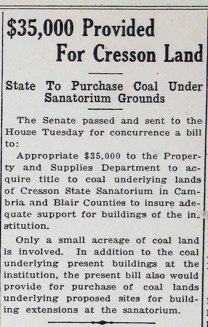
Newspaper on July 20, 1941 and shows that there were coal shafts running underneath the san grounds and buildings. ________________________
Cresson Water Tank
The author describes several of the modern steel watchtowers of the State
Department of Forests and Waters which are in Cambria County. In describing the Chickaree tower in the vicinity
of the William Penn Highway near the Cambria/Indiana County line, he mentions that the Cresson Sanatorium water tank, near
the crest of the Allegheny Mountain, is a landmark to the east.
Click on the following link to read the full account:
|
|
|
|
|
|